Directions
Directions to Cordell Bank National Marine Sanctuary offices (co-located at Point Reyes National Seashore)
*Note that cell phone coverage between 101 and Olema varies and gradually diminishes for most cell phone carriers as you head west to Olema
*Note: The sanctuary offices are administrative work spaces and closed to the public. If you are trying to contact a staff person, visit this page.
From 101 (closest to San Francisco/GG Bridge)
Route takes you over Mount Tam: (beautiful, windy road, steep cliffs, incredible
vistas)
From 101 north or south
Take Stinson Beach, Tam Valley exit
At the intersection in Tam Valley, take a left onto Shoreline Hwy (Route 1)
After a few miles, it splits to go either straight to Stinson Beach or right to Mount
Tam.
Take the right to Mount Tam (it also goes to Stinson, and is quicker)
Take all the way to Stinson Beach
Make a right when you get to stop sign at Route 1
Go through Stinson Beach (still on Route 1)
Go around Bolinas Lagoon (look for harbor seals on your left at low tide!)
Keep going, for about 15 miles until you get to Olema!
Go straight through blinking stop light (after stopping!)
Make left onto Bear Valley Road
Make first left into Park Headquarters, then turn right and follow road across creek
bridge
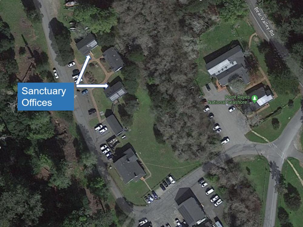
Keep right and pass 2 white buildings and park either on left side or in parking lot
GFNMS/CBNMS offices are the two buildings facing each other (one on left has solar panels on roof,
one on right has two skylights on roof)
From 101 North/or South
Route takes you through the towns of Ross, San Anselmo, Fairfax, Forest Knolls, and
Lagunitas: can be trafficy, lots of stop lights
From 101 north/south
Take San Anselmo Exit onto Sir Francis Drake Blvd.
Stay on Drake all the way to Olema
You'll get to a major traffic hub in downtown San Anselmo, where there is a large 1924
Spanish Colonial Revival style building, which was built in 1924 as a garage and car sales
showroom.
Just keep going straight on Drake you'll go through Fairfax, Lagunitas, then Samuel P.
Taylor park (lots of redwood trees and along Lagunitas creek)
Continue all the way to blinking red light in Olema; make right, then quick left onto Bear
Valley Road.
Make first left into Park Headquarters, then turn right and follow road across creek
bridge
Keep right and pass 2 white buildings and park either on left side or in parking lot
GFNMS/CBNMS offices are the two buildings facing each other (one on left has solar panels on roof,
one on right has two skylights on roof)
From 101 North/South
San Rafael exit (route bypasses town of Ross, but merges with other 101N/S
route)
Coming from north or south via 101, take Central San Rafael Exit.
Turn West onto 4th Street, take until it joins up with Sir Francis Drake Blvd (about 5
miles)
Bear right to stay on Sir Francis Drake Blvd. You'll go through the towns of San Anselmo,
Fairfax, Lagunitas, then Samuel P. Taylor State Park (lots of redwood trees and Lagunitas
creek)
Continue all the way to the blinking red light at Olema; make a right, then quick left onto
Bear Valley Road.
Make first left into Park Headquarters, then turn right and follow road across creek
bridge
Keep right and pass 2 white buildings and park either on left side or in parking lot
GFNMS/CBNMS offices are the two buildings facing each other (one on left has solar panels on roof,
one on right has two skylights on roof)
From 101 Lucas Valley Road Route
This route is the least amount of traffic, but is a very windy road and somewhat slow, be
careful watching for bicyclists on this route. Lots of redwood trees and rolling
hills!
From 101 north/south take the Lucas Valley Road Exit and head west.
(From the south, take a left onto Lucas Valley Road, from the north; stay right onto Lucas
Valley Blvd.)
Continue on all the way to a stop sign near the town of Nicasio.
You will go through rolling hills, and lots of redwood trees and oak groves.
At the stop sign (end of Lucas Valley Road), turn right (onto Nicasio Valley Rd.).
Take all the way to end where there is a stop sign and take a left onto Point Reyes Petaluma
Blvd. you'll hit a stop sign at a bridge.
Go straight towards Olema, this turns into Platform Bridge road.
At next stop sign (end of road) make a right onto Sir Francis Drake Blvd.
When you get to the end and hit the town of Olema at the blinking red light, turn right,
then quick left onto Bear Valley Road.
Make first left into Park Headquarters, then turn right and follow road across creek
bridge
Keep right and pass 2 white buildings and park either on left side or in parking lot
GFNMS/CBNMS offices are the two buildings facing each other (one on left has solar panels on roof,
one on right has two skylights on roof)
From 101 Novato Area
From 101 take the Rowland Boulevard exit.
From 101 south, turn left over the freeway, from the north turn right and head west.
Stay on this road until you hit Novato Blvd just past.
Turn right on Novato Blvd.and; go all the way to the end.
At the intersection make a left onto Point Reyes Petaluma Blvd.
Continue on Petaluma/Point Reyes Blvd. until you come to the stop sign at the intersection
of Platform Bridge Road (about 7 miles).
Go right across bridge to stay on Point Reyes Petaluma Road.
Continue about three miles to intersection with Route 1.
Turn left (South) on Route 1 and follow it through Point Reyes Station and over the Green
Bridge.
Go Straight (continuing on Route 1). Make right onto Bear Valley Road
Make first left into Park Headquarters, then turn right and follow road across creek
bridge
Keep right and pass 2 white buildings and park either on left side or in parking lot
GFNMS/CBNMS offices are the two buildings facing each other (one on left has solar panels on roof,
one on right has two skylights on roof)
From 101/ Petaluma Area
Take Washington Ave exit and head west, turn left onto Lakeville Blvd, and turn right onto
East D Street.
Continue west on D Street and it turns into Point Reyes - Petaluma Blvd at the west edge of
town.
Continue on Petaluma/Point Reyes Blvd. until you come to the stop sign at the intersection
of Platform Bridge Road (about 15 miles).
Go right across bridge to stay on Point Reyes Petaluma Road.
Continue about three miles to intersection with Route 1.
Turn left (South) on Route 1 and follow it through Point Reyes Station and over the Green
Bridge.
Go straight (continuing on Route 1). Make right onto Bear Valley Road
Make first left into Park Headquarters, then turn right and follow road across creek
bridge
Keep right and pass 2 white buildings and park either on left side or in parking lot
GFNMS/CBNMS offices are the two buildings facing each other (one on left has solar panels on roof,
one on right has two skylights on roof)